 2015 too, France was our holiday destination. This year we have chosen the Cevennes in the region Languedoc/Roussillon . Our resort was Sauve in the departement Gard. We had booked a cheap holiday home in a holiday resorton the outskirts of the village of Sauve via Interchalet .
Wednesday, July 29, 2015
Residence Les Portes des Cevennes (2015)
2015 too, France was our holiday destination. This year we have chosen the Cevennes in the region Languedoc/Roussillon . Our resort was Sauve in the departement Gard. We had booked a cheap holiday home in a holiday resorton the outskirts of the village of Sauve via Interchalet .Sauve - The Village
 |
| The medieval Sauve |
Sauve is located on a slope. That's why they have so much up and downs.
The Sea of Rocks
 |
| La Mer de Rochers |
Outside of the territory of the town of Sauve is the Sea of Rocks,la Mer de Rochers. It's a chaotic tangle of limestone rocks above the town. A small walking track of about 4 km leads through it. This is a typical karst area.
The Camargue
 |
| [Click on photos to enlarge] |
A Saturday in Marseille
 |
| [Bilder anklicken zum Vergrößern] |
A Sunday in Marseille
| [Click photos to enlarge] |

The Mont Aigoual

On 05.Juni 2015, we went into the mountains to the second highest mountain of the Cevennes, the Mont Aigoual. First, our path led on the D 999 to Saint-Hippolyte-du-Fort. That's a pretty small place, just 8km from Sauve. That was our place to shop substantially. On Tuesdays and Fridays there was market. We made a short stop to see what the market offers everything so. As usual in France throughout a visit to the market is always a special experience. The local farmers offer fresh fruits and vegetables, sausages and especially cheese. Specialty in the Cevennes is a goat's milk cheese, the Pelardon, which is available in three levels of maturity. We enjoyed especially the least-ripened cheese.
 |
| Junction to Valleraugue (Source Google Streetview) |
In Valleraugue we make a short stop, a village in about 300m altitude with nearly 1,000 inhabitants but its area reaches up to the Mont Aigoual. Small hotels and restaurants are located on the main road that runs parallel to the river Hérault.
 |
| Valleraugue |
 |
| Valleraugue |
After a short break with village tour and visit to the Tourist Office, we will continue our journey. A steady but initially not very steep ascent takes us through the beautiful Hérault Valley up to 8 km the road climbs to a left turn up a steep mountainside in numerous serpentines. In some curves are lookout points, where we have wonderful views of the valley and back to Mont Aigoual. The small, inconspicuous settlement L'Esperou in 1230 m height with its hotels let realize that this area is a popular winter sports area.
 |
| Col de Serreyrède 1299 m |
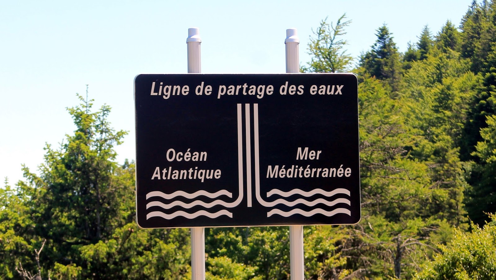 |
| The watershed |
A few kilometers further we arrive at the pass Serreyrède. It is interesting that this is the watershed for the springing rivers in the Cevennes. To the south, the waters flow into the Mediterranean Sea, to the north into the Atlantic. Here we stopped for some minuts. A small organic shop here offers products of the region. But then it's just a "stone's throw" (7km) on the top of the mountain. The height however it is still a leap from 1300 to 1567m.
 |
| In front of us we see the summit |
That a road leads here to the summit, is probably the weather station and the observatory due to having their place up here. A restaurant is also here with a terrace where we had taken a little refreshment. Of course you have a wonderful view in all directions. The top of the hill is deforested. Allegedly, one should be able to see in good visibility one-quarter the size of France.
 |
| On this path we have made a little walk |
 |
| At the top |
 |
| Serpentines uphill |
The way back we also initially selected via the pass Serreyrède, but have then used the D 323 to Le Vigan. There we visited the small town and then drove back to the D999 back to Sauve.
 |
| View of the Cevennes |
The Tarn Gorge
 |
| [Click all for enlarge] |
 |
| Der Viaduc de Millau |
The technical data I will skip. You can read them here . Definitely an impressive building. But it has the disadvantage: you have difficulties to take photos of the whole building. For this purpose, we would have to drive on the autobahn to the (not free) observation platform. But we were too stingy. Since we would have had to pay € 7 toll! Maybe another time.
"Les Causses" and "Les Cevennes" are cultural landscapes on the southern slopes of the Massif Central. While the Cévennes are rich of gorges and wooded karst mountains, the Causses are hilly, mostly barren plateaus. The mountains in the Cevennes reach heights of up to 1700 meters. Two great mountain ranges characterize the Cevennes, the Aigoual in the south and the Lozère - massif in the north
The Cevennes were in the history the center of the French Protestants, the Huguenots.
Here they were able to hide in the many gorges and caves during the religious wars in the 17th century.
The high levels of Caussses are at an altitude of 900 - 1200 meters. The porous, water-permeable limestone has created a specific, sparse vegetation, which is only suitable for grazing by goats and sheep.
The famous gorge of Tarn, the Gorges du Tarn is not far, because it starts behind Millau. Specifically, it starts in the village of Le-Rozier and ends in Sainte-Enimie. It is 35 km long and in some cases very tight, but not so tight that not a road fit between them.
The high levels of Caussses are at an altitude of 900 - 1200 meters. The porous, water-permeable limestone has created a specific, sparse vegetation, which is only suitable for grazing by goats and sheep.
Even though the road is very narrow through the gorge, there are always lookouts, where you can stop and enjoy the breathtaking scenery. There are few localities in the canyon. The most known ones are La Malène and Sainte Enimie. They live from hiking and canoe tourism. La Malène has just 158 inhabitants, but a beautiful Romanesque church and a castle "Manoir de Montesquiou" now used as hotel. Sainte-Enimie is the main town of the canyon with about 500 residents.


After a short break in Sainte Enimie we left the gorge. We turned and drove on the D986 at first towards Mende. Now it went uphill in some serpentins. A relatively long time we drove directly above the gorge. Eventually, the road number converts to the D998. We have crossed a border of department (Lozère) .The D-road numbers are changed. We passed also relatively barren plateaus, the Causses Sauveterre. There, where the D998 meets the D32, we got lost. Instead of driving toward Le Massegros, we turned right towards Chanac. After 2-3 km we noticed it, and we turned and drove along the right D32. Sparsely populated this area is here. We pass Le Massegros, a very small village and now we are going downhill. From the department's border of Aveyron the D32 bebomes the D9 which in some zigzags winds down. In Le Rozier we went back on the Tarn-road on which we came. Now we are back on familiar territory. In Millau, we even sometimes a beautiful bridge view.

Tuesday, June 24, 2014
Les Alpilles 2014

The total distance of 1300 km from Halle to Mouriès we don't complete in one day . After 800 km we have a stay in Besançon in the hotel Zenitude. We have been there. It is located in the western outskirts of the city next the medicine department of the university and very reasonably priced
Mouriès
 |
| Olive plantations -far and wide |
Mouriès is a village south-east of Avignon, on the southern slope of the Alpilles, a mountain range even not all French are knowing. The maximal height of the most white looking limestone rocks is 400 meters. The mountain ridge is visible on the horizon in the north. 3500 residents live here and have to do -mainly- with oil. With olive oil of course. Around the village are large olive plantations. There is the main and biggest growing area of olives in France. There are some oil mills there - even with factory shops. But the oil prices are so high (15 - 20 euros per liter)that we prescinded from purchase.
But also almonds and grapes are grown there.
Mas des Arenes
[click the photos to enlarge]
This was the name of our holiday resort. A "Mas" is a Provençal country cottage. This designation you will find often for rural inns or hotels. In fact, our "mas" was directly next the arena, the bullfighting arena. Therefore the name.
Now, our holiday resort:
It is a colony of holiday homes grouped around a big swimming pool. A sufficient parking lot is directly in front of the reception. It is protected by a security code. Friendly young ladies speaking French and English (but not German!) manage the daily business.
This was the name of our holiday resort. A "Mas" is a Provençal country cottage. This designation you will find often for rural inns or hotels. In fact, our "mas" was directly next the arena, the bullfighting arena. Therefore the name.
Now, our holiday resort:
 |
| The swimming pool was the centre of the resort |
Trip to Marseille

Bullfighting à la Camargue
 That we had not expected. Almost immediately next to us was the bullring. A poster announced a bullfight on 31 May.
Of course we were there. The entrance costs 5 euros. The cashier was easily too be overlooked, a small opening in the outside wall. It was beautiful summer weather. Full of anticipation we entered the arena and looked for a shady place. We were surprised that so many seats remained vacant. The word "jeune" (young) probably explains the character of the struggle that we got to see. Each bullfight -also ours- begins with the Carmen overture,sounding tinnily from the loud speakers.
Saturday, June 2, 2012
The Loire Castles 2012
The vacation in the year 2012 should be a "little flatter" - that means vacation in the flat country. We thought, the valley of the Loire in France would be just the right place.
We booked with Interchalet a reasonably priced summer cottage near Chinon. Near- that means a lonesome hamlet in La Roche-Clermault, 6 kilometers away from Chinon. The cottage was not a palace but absolutely sufficient for 4 persons. It's notable: the house was in the midst of the winery of Monsieur Bruno Préveaux.
There are a lot of palaces and castles in the surroundings. Many vineyards there look like small chateaux, and in the great and big castles was written a considerable part of the French history.
Chinon itself is located at the river Vienne, an affluent of the Loire,a picturesque, medieval town with a big castle high above the city and many small streets, lanes and squares.
The surroundings of the cottage is lovely and bicycle-friendly. You can easily bike on asphalted roads and farm tracks between vineyards and grainfields. You pass small hamlets, villages and lonesome farms. But it's only right at nice weather. We had'nt every day. Almost every day we had one rain shower, at least!
Monsieur Préveaux' excellent red and rosé wine took comfort in the bad weather. And the visits in the marvellous castles and abbeys were a good compensation for rain, wind and low temperatures.
The surroundings
 |
| The wheat for the typical French baguettes is growing here. |
 |
| Old willow near La Roche Clermault |
 |
| The vineyard looks like a small "chateau". |
The first day was sunny. We were hoping for nice summer days. First we explored the immediate surroundings.
 |
| A nice summery landscape, isn't? |
 |
| The wine of Chinon is one of the best in the Loire region. |
 |
| The vineyards are very well maintained. |
Subscribe to:
Posts (Atom)